Hadrian's Wall Worksheets
Do you want to save dozens of hours in time? Get your evenings and weekends back? Be able to teach about the Hadrian's Wall to your students?
Our worksheet bundle includes a fact file and printable worksheets and student activities. Perfect for both the classroom and homeschooling!

Resource Examples
Click any of the example images below to view a larger version.
Fact File


Student Activities


Summary
- History of the Wall
- Building the Wall
- The Wall After Hadrian
- Hadrian’s Wall Sites
Key Facts And Information
Let’s find out more about Hadrian’s Wall!
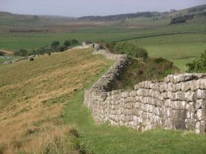
Hadrian's Wall served as the northernmost boundary of the Roman Empire for about three centuries. Following Emperor Hadrian's visit to Britain in 122 CE, the Roman troops constructed the wall. It spanned northern Britain from Wallsend on the River Tyne in the east to Bowness-on-Solway in the west, a distance of 73 miles (80 Roman miles). Hadrian's Wall consisted of a series of forts and a ditch meant to prevent invading forces. In several locations, traces of a stone wall can still be seen.
Background
- Roman Britain was the period in ancient history when the Roman Empire occupied vast portions of the island of Great Britain. The occupation lasted between 43 and 410 CE. During this period, the captured region was elevated to the status of a Roman province.
- Hadrian ruled the Roman Empire from 117 to 138 CE. He favoured investing in the building of stable, defensible frontiers and the union of the diverse peoples of the empire. He is famous for constructing Hadrian's Wall, which established the northern boundary of Britain.
- Hadrian's Wall was almost certainly planned prior to Hadrian's journey to Britain in 122. "If there are difficult tribes to the north, and you want to keep them out, you build a formidable defence wall," one commentator said of the wall's military purpose.
- On Hadrian's accession to the imperial throne in 117, there was turmoil and insurrection in Roman Britain and among the conquered populations of Egypt, Judea, Libya, and Mauretania, among others.
- These difficulties may have impacted his decision to build the wall and the construction of boundary barriers in other parts of the Roman Empire, such as the Limes Germanicus in modern-day Germany.
- According to the Historia Augusta, Hadrian was the first to construct a wall 80 miles (130 km) from sea to sea to isolate the barbarians from the Romans.
- In addition to serving as a barrier to keep outsiders out, the wall also prevented people from leaving the Roman province. Since the Romans controlled who could enter and leave the empire, the wall was indispensable for regulating commerce and the economy.
- The Wall also provided years of employment for thousands of soldiers who were responsible for constructing and maintaining the barrier, preventing the soldiers from becoming bored.
- Hadrian's Wall was not just a fortification, but also a symbol of Rome's imperial supremacy, marking the boundary between the so-called civilised world and the unconquered barbarian wilderness.
Building the Wall
- The length of the wall was 73 miles (117 kilometres). This extended from the easternmost city of Wallsend on the River Tyne to the westernmost city of Bowness on the Solway.
- Bede, a medieval historian, claimed that the wall measured 12 feet (4 metres) in height, while evidence suggests that it may have been a few feet taller when it was initially constructed.
- R. S. O. Tomlin claims that every three miles along the wall there would have been a tower, increasing the size of the structure, as evidenced by the abundance of turret remnants.
Hadrian’s Wall location - Beginning in 122, the entire length of the wall was constructed with an alternating sequence of forts, each sheltering 600 men, and manned milecastles, each operated between 12 to 20 men.
- The majority of Hadrian's Wall was constructed over the course of six years by 15,000 Roman soldiers from three legions (the Legio II Augusta, Legio VI Victrix, and Legio XX Valeria Victrix) and the Roman fleet.
- The wall's defences were bolstered by a northern ditch, a military road, and an earthwork known as the vallum. Together, these elements constituted a military zone that restricted the movement of individuals north and south of the wall. This military zone was off-limits to all armed barbarians.
- Broad sections of the wall are approximately nine and a half feet (2.9 metres) broad, while small sections are approximately two feet (60 centimetres) narrower, measuring approximately seven and a half feet (2.3 metres) wide.
- It was discovered that the narrow sections were constructed on broad foundations. R. G. Collingwood argued, based on this evidence, that the wall was initially intended to be constructed between present-day Newcastle and Bowness, with a constant width of 10 Roman feet and made entirely of stone.
- In the end, only three-fifths of it was constructed from stone, with the remainder in the west consisting of a turf wall that was later rebuilt from stone. It is possible that plans were altered owing to a shortage of resources.
- In an effort to conserve resources further, the width of the eastern half was decreased from the original ten Roman feet to eight, and the surviving stones from the eastern half were used to construct around five miles (eight kilometres) of the western turf wall. This reduction from ten Roman feet to eight feet produced the so-called "Narrow Wall."
The Vallum
- The Vallum is a 10-foot-deep (3-metre-deep), ditch-like structure with two parallel mounds running north and south just south of the wall.
- Between the forts of Newcastle and Wallsend at the east end, the Vallum may have been deemed unnecessary as a barrier due to the close vicinity of the River Tyne.
- The Vallum is believed to have been built after the completion of the wall, as it deviates to the south around multiple wall-forts that were either completed or under construction as the wall neared completion.
The Turf Wall and Milecastle
- From Milecastle 49 to the wall's western termination at Bowness-on-Solway, the curtain wall was initially made from turf, probably due to a lack of limestone for the production of mortar. The Turf Wall was subsequently removed and replaced with a stone wall.
- Archaeologists have proposed various hypotheses for why the western portion of Hadrian's Wall was first constructed of turf. One explanation suggests that wood and turf were more accessible in the west, but handy stone outcrops were limited.
- A milecastle was a fortlet and a rectangular defence system constructed during the Roman Empire. They were placed at approximately one Roman mile intervals along numerous major borders.
- A turret was a small watchtower that was integrated into Hadrian's Wall. The turrets were typically separated by a third of a Roman mile (equal to 495 metres; 541 yards) between Milecastles, giving each Milecastle two Turrets.
Garrison
- When Hadrian's Wall was finished and fully manned, it's estimated that approximately 10,000 soldiers were stationed there. These soldiers weren't from the legions that had built the wall; instead, they were regiments of auxiliary infantry and cavalry recruited from the provinces.
- David Breeze, a British archaeologist and scholar of Hadrian's Wall, outlined the two primary responsibilities of soldiers stationed at or near Hadrian's Wall.
- Breeze claims that in addition to their primary function of defence, the soldiers stationed in the milecastles and turrets along the wall also had the duty of border control. According to Breeze, the evidence is much more pronounced for soldiers stationed in forts than it is for those in milecastles and turrets.
- Although there is little information available regarding civilians in the early years of the Wall, excavations and geophysical studies have revealed indications of large towns in the vicinity of the forts by the third century. Veterans, merchants, and families of the garrison lived and worked in these villages.
The Wall After Hadrian
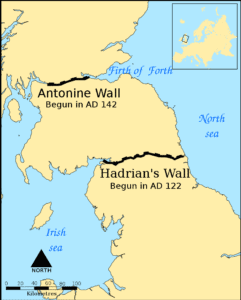
- The wall was essentially abandoned after Hadrian's death in 138 by Antoninus Pius, the new emperor, who left it occupied in a support capacity. About 160 km (100 km) north of where he started, across the isthmus that runs from west-southwest to east-northeast, he started construction on the Antonine Wall. This turf wall featured more forts than Hadrian's Wall and was longer by 40 Roman miles, or 60.8 km (37.8 mi). Later, this region came to be known as the Scottish Lowlands, also known as the Central Belt or the Central Lowlands.
- Since Antoninus was unable to subdue the northern tribes, Emperor Marcus Aurelius abandoned the Antonine Wall in 164 and replaced it with Hadrian's Wall as the main defensive line.
- The Antonine Wall was briefly reoccupied by the Emperor Septimius Severus during the years 208–211 while he attempted to conquer Caledonia once more.
- The Romans ultimately withdrew to Hadrian's Wall after the campaign ended inconclusively.
- Invasion by barbarians, a drop in the economy, and military coups at the end of the 4th century weakened the Empire's hold on Britain.
- By 410, which is when Roman rule in Britain is thought to have ended, the Roman government and its legions had left, leaving Britain to take care of its own defence and government.
- Archaeologists have found that people still lived in some parts of the wall as late as the 5th century.
Hadrian’s Wall Sites
- When the Wall was abandoned, its deteriorating ruins served as a convenient source of building materials for the castles, churches, and farms along its path. As a prominent landscape feature, it was used to distinguish parishes and estates. Over time, it drew not only archaeologists and historians but also painters, photographers, poets, and writers. Its popularity continues to attract travellers from throughout the world.
- In 1987, Hadrian's Wall was designated a World Heritage Site because of its historical and cultural significance.
- A National Trail pathway that follows the wall from Wallsend to Bowness-on-Solway was inaugurated in 2003. Due to its delicate nature, walkers are only permitted on the trail during the summer.
- Hadrian's Wall is a popular tourist attraction, and it was included in The Guardian's 2017 list of "Where to Go."
- The remnants of Hadrian's Wall include not just the Wall itself but also a number of related structures such as towers, forts, turrets, milecastles, ditch, bridges and temples.
- The Sycamore Gap tree stands in a dramatic drop along Hadrian's Wall and is one of the most photographed trees in the country. Roman Milecastle 39 is located just to its left. In late 2016, it was named the English Tree of the Year by the Woodland Trust.
Preservation of the Wall
- Hadrian's Wall served as a source of stone for the construction of castles, churches, farms, and homes along its length, until the conservation movement of the 18th and 19th centuries put an end to this practise.
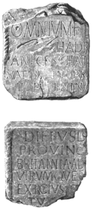
In 1782, two Roman inscriptions were discovered built into St. Paul's Church in Jarrow, naming Hadrian and the Province of Britannia, respectively. They may have originated from a dedication slab or a triumph monument near the easternmost end of the Wall. - Only after the mid-19th century did early archaeologists and historians such as John Clayton, John Hodgson, and John Collingwood Bruce begin to study Hadrian's Wall in an earnest attempt to preserve its remarkable remains.
- John Clayton began purchasing the surrounding land to prevent local farmers from taking stones from the ancient wall to construct houses and/or roadways. He established farms in the area and used the earnings to support the excavation and restoration of Hadrian's Wall.
- The most significant developments of the past decade were:
- Determining the course of Wall and Vallum planning.
- The discovery of writing tablets at Vindolanda and Carlisle beginning in 1973, which provide numerous insights into life on the Roman frontier.
- The geophysical survey has substantially expanded our understanding of the size of civilian communities outside the forts.
- Dendrochronology has enabled us to precisely date the timbers used to build forts.