Download The Ho Chi Minh Trail Worksheets
Do you want to save dozens of hours in time? Get your evenings and weekends back? Be able to teach The Ho Chi Minh Trail to your students?
Our worksheet bundle includes a fact file and printable worksheets and student activities. Perfect for both the classroom and homeschooling!

Resource Examples
Click any of the example images below to view a larger version.
Fact File


Student Activities


Table of Contents
Add a header to begin generating the table of contents
Summary
- The factors behind the establishment of the Ho Chi Minh Trail
- The key features of the Ho Chi Minh Trail
- The methods used by the US government to suppress the Ho Chi Minh Trail
Key Facts And Information
Let’s find out more about the The Ho Chi Minh Trail!
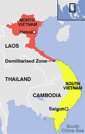
- The Ho Chi Minh Trail was a highly organised system of routes running from North Vietnam and along the Truong Son Mountain Range that passed through neighbouring countries Cambodia and Laos. It was a 16,000-kilometre (9,940-mile) network of tracks, dirt roads and river crossings that served as a lynchpin for Northern Vietnamese forces amidst the revolutionary warfare.
- The route began in North Vietnam in a gorge called ‘Heaven’s Gate’.
- The main aim of US military actions in the Vietnam War was to disrupt the movement of supplies along the trail.
- The trail was considered one of the greatest feats of warfare because the North Vietnamese government was able to keep the trail open even in the face of relentless American attacks.
- The Ho Chi Minh Trail did not comprise just one trail. It consisted of over 12,000 miles of trails.
- Between 1959 and 1975, over two million soldiers from the Northern Communist government traversed it.
- The establishment of the trail began in 1959 on the 69th birthday of the North Vietnamese president, Ho Chi Minh.
- The North Vietnamese used trucks, special bikes and horses to carry supplies along the trail.
- The camouflaged network of roads and footpaths was considered one of the world’s most dangerous routes.
- There were nearly a dozen ways to die on the trail. Snakes could poison you; tigers could eat you. You could also get blown to pieces by US aerial bombardments.
- More than 1.7 million tons of bombs were dropped by the United States to try and shut down all the activities that were taking place along the Ho Chi Minh Trail. The roads were littered with scorched vehicles and charred bodies.
- It was the Americans that named it the Ho Chi Minh Trail after the North Vietnamese president. It was originally called Truong Son Road.
- The trail served as a sanctuary for the communist forces in Laos, from where they could attack South Vietnamese targets.

- The Vietnam War was a war that involved South Vietnamese and communist North Vietnamese soldiers. The United States was involved because it backed the South Vietnamese forces in a bid to curb the spread of communism. Since the United States was a superpower, the South Vietnamese forces should have technically won the war over the North, but this was not the outcome.
- A lot of factors made victory for the US-backed forces impossible. One key factor was the Ho Chi Minh Trail. The Ho Chi Minh Trail consisted of a network of roads that were built from North Vietnam to South Vietnam and passed through neighbouring countries Cambodia and Laos. The roads were very important because they provided logistical support to the North Vietnamese army and the Vietcong during the war. The trail was a combination of truck routes, bike paths and footpaths. It was 16,000 km long and even consisted of waterways.
- The Americans gave the trail its name, after Ho Chi Minh, the leader of North Vietnam. In Vietnam, the road was called Truong Son Road. The Vietnamese named it after the mountain range in Central Vietnam.
Formation of the Ho Chi Minh Trail
- In 1959, the Communist Party in Vietnam, the Lao Dong Party, decided that they needed to increase support to the communist insurgencies that were taking place in South Vietnam.
- On the birthday of the North Vietnamese leader Ho Chi Minh, 19 May 1959, the Major General of the North Vietnamese army instructed the army to construct the 559th Transportation Group. The project was to be under the command of a general named Vo Bam. The objective of the Transportation Group was to establish a supply route that ran through the country from the North to the South of Vietnam.
- Vo Bam began the construction of the trail using ancient footpaths that ran from north to south and had connected the regions for centuries with depots, command posts and staging areas along the trail. By August 1959, supplies were already being delivered from the North through the trail.
- The first supplies to be delivered consisted of 20 boxes of ammunition and rifles that were delivered to the Viet Cong insurgents in the South. By the end of 1959, nearly 1,800 men had travelled along the Ho Chi Minh Trail into South Vietnam.
- The expansion of the trail continued into the early 1960s. North Vietnam also developed a new route in Laos’ territory along the western side of the Truong Son Range. This new route was developed for secrecy. North Vietnam’s government also established training centres at Son Loc and Xuan Mai to train soldiers on how to camouflage themselves while they were moving along the roads.
- The Northern Vietnamese government then introduced bicycles to replace porters on foot. With this improvement, soldiers could now move twice as fast and carry three times as much load.
- In December 1963, 5,000 troops were assigned to maintain the trail, which stretched for more than 600 miles.
Expansion of the Trail
- During the early 1960s, the North Vietnamese government in Hanoi campaigned for a massive improvement of the trail. This was done in secrecy. Hence, the trail was more than just a series of jungle trails; it was a political, strategic and economic anchor of the ongoing war. Consequently, engineers were designated to expand the walkways into flat roads. Bridges were improved to support truck convoys able to transport soldiers at night.
- In 1965, the North Vietnamese government in Hanoi launched massive campaigns to improve the trail. Several engineers were assigned to widen the footpaths into flat roads. The engineers also strengthened the bridges to make them capable of supporting truck movement and Hanoi could now use truck convoys to transport troops at night. The North significantly increased supplies to their troops in the South.
- In 1966 and 1967, the war became more intense and the Ho Chi Minh Trail became more and more important to Hanoi. Supplies were now transported at night by trucks and personnel were positioned at vulnerable points to maintain and repair trucks that broke down.

- At every third and fifth point between stations, refuelling points were set up. The role that the trail played in the war effort alerted US planners and made them think of ways they could cut off the supply route.
Operation Commando Hunt: Interdiction
- In 1966, the US Secretary of Defense, Robert McNamara, wrote a letter to the President of the United States. In the letter, McNamara described the Ho Chi Minh Trail as one of their biggest problems. Several operations were launched by the US to try and disrupt the movement of supplies using small ground units.
- Unfortunately for the US, these operations, including Operation Leaping Lena and Operation Shining Brass, failed. In 1964 and 1965, the US also carried out aerial bombardment of the trail. This was known as Operation Rolling Thunder. The trail still managed to operate and the bombings did not slow down the activities along the trail.
- Air and ground raids by US forces became common knowledge and were supported by American media. The US State Department had no choice but to announce that these controversial missions were authorised by then-president Lyndon B. Johnson. The Johnson administration therefore was met with a lot of criticism both at home and abroad. Everyone criticised the bombing along the trail in Cambodia and Laos.
- The bombing of the trail stopped when the US suspended the bombing of North Vietnam. America then turned its attention to interdiction leading to the launch of Operation Commando Hunt on 15 November 1968. This operation intended to prevent the movement of personnel and supplies along the trail.
- In 1969, around 9,000 trucks were destroyed and the number grew to 12,000 during 1970. To protect the trail, the government in Hanoi set up anti-aircraft artillery. Despite the heavy bombardments, the Ho Chi Minh Trail continued to facilitate the movement of 8,000 troops and 10,000 tons of material that were used in the war. This meant that none of the efforts by the US to destroy the trail succeeded. The war could not be won. Due to the extreme loss of life, the trail became known as ‘The Blood Road’.
The Last Years
- Operation Commando Hunt and Operation Lam Son ended as failures in 1971.
- After the signing of the Paris Peace Accords in 1973, interdiction efforts declined significantly. The trail, therefore, continued to improve. By the end of 1973, the Ho Chi Minh Trail had become a two-way highway that ran from North Vietnam to South Vietnam.
- By 1974, the trail expanded into a four-lane highway and also boasted four oil pipelines. The government of Hanoi had won the battle of supply in which the trail had played a vital role.
- Today, the series of paths along the trail remains unchanged to this day. The paths link isolated communities and mountain passes as they work their way between the once-divided parts of Vietnam. The trail today offers a glimpse of the key aspects of military engineering, which really made a pivotal difference in the outcome of the conflict.
Image sources: