Proclamation Line of 1763 Worksheets
Do you want to save dozens of hours in time? Get your evenings and weekends back? Be able to teach about the Proclamation Line of 1763 to your students?
Our worksheet bundle includes a fact file and printable worksheets and student activities. Perfect for both the classroom and homeschooling!

Resource Examples
Click any of the example images below to view a larger version.
Fact File


Student Activities


Summary
- Historical background
- Proclamation Act 1763 and other treaties
- Response from colonists
- Legacy of the act
Key Facts And Information
Let’s know more about the Proclamation Line of 1763!
The Proclamation Line of 1763 was a boundary drawn by the British in the Appalachian Mountains near the Eastern Continental Divide. The Proclamation Line, established on 7 October 1763, banned Anglo-American colonists from settling on territory acquired from the French following the French and Indian War. This legislation aided British government efforts to inhibit westward growth in the decade preceding the American Revolution, a goal prompted by various social, political and economic causes. Officials in London were concerned that an increased Anglo-American presence in the western territories would fuel Indigenous peoples’ aggression, which, combined with resistance from French residents in the region, would spark another costly struggle for the empire.
HISTORICAL BACKGROUND
- Following the French and Indian War, the Treaty of Paris was drafted, officially ending the war and awarding the British extensive territories in North America. The Ohio Valley between the Appalachian Mountains in the east and the Mississippi River in the West was obtained by the British. It provided the British with access to vital commercial routes and introduced a many of new issues.
- The French and Indian War (1754–1763) was a theatre of the Seven Years’ War that pitted the British Empire’s North American colonies against those of the French, with each side supported by various Indigenous peoples.
- All French colonial territory west of the Mississippi River was sold to Spain. In contrast, all French colonial territories east of the Mississippi River and south of Rupert’s Land were handed over to Great Britain (except for Saint Pierre and Miquelon, which remained in French hands).
- Spain and Britain each received certain French Caribbean islands, while France retained Haiti and Guadeloupe.
- Despite their efforts to conquer more land during the French and Indian War, the British attempted to prevent American colonists from settling there. It was already difficult for them to control the colonies from afar. The British feared that if Americans crossed the mountains, it would be too challenging to oversee trade and taxation, and their resources would be exploited.
- Furthermore, numerous people already lived on the land in the Ohio Valley. Although the French government had given this territory to Britain, the French settlers did not relinquish their claims to land or trade routes.
- Because the British could not afford another war, they left the French settlers alone in those territories. Other people had settled in the Ohio Valley as well.
- Even though the French and Indian War was over, Indigenous peoples who aided the French were still fighting over land. Even after the Europeans declared a ceasefire, a huge war called Pontiac’s Rebellion raged.
- The British government did not want American colonists to cross the Appalachian Mountains and cause conflict with the French and Indigenous peoples. As a result, the British government issued the Royal Proclamation of 1763, which defined the thirteen colonies’ borders as the Appalachian Mountains. Beyond the mountains, any travel or settlement would be illegal.
- The Thirteen Colonies were a set of British colonies established on North America’s Atlantic coast in the 17th and 18th centuries. The American Enlightenment precipitated the American Revolutionary War in these colonies.
- Colonists widely despised the Royal Proclamation Line of 1763. Creating a boundary was ineffective for individuals living in the colonies since it did not address some of their most pressing concerns about the war.
- Many colonists believed they had earned the right to settle on the territory they had acquired by fighting the French and Indigenous peoples. Furthermore, the Royal Proclamation Line of 1763 did not consider American colonists who had already established themselves in the West.
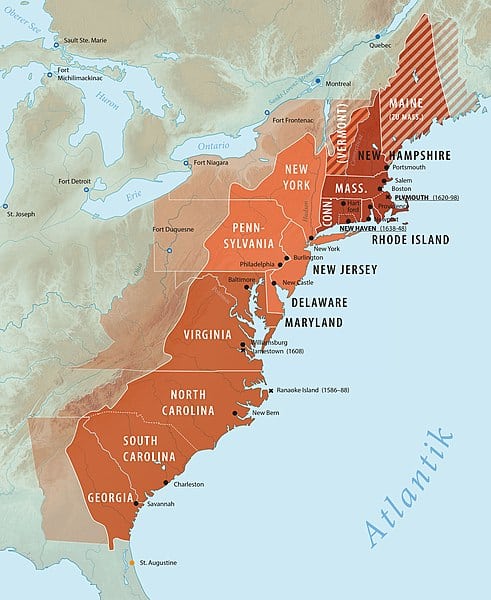
Map showing the Thirteen Colonies
PROCLAMATION ACT 1763 & OTHER TREATIES
- The Proclamation Line of 1763 dealt with the control of former French territory in North America that Britain gained after defeating France in the French and Indian War and the growth of colonial settlers. It established new governments for many locations, including the province of Quebec, the new colonies of West and East Florida, and a series of Caribbean islands known as the British Ceded Islands, which included Grenada, Tobago, Saint Vincent and Dominica.
- The Royal Proclamation Line of 1763 established the jurisdictional bounds of British North American possessions, limiting British colonial development on the continent.
- The territory east of the Great Lakes and the Ottawa River and south of Rupert’s Land was renamed Quebec. In contrast, the territory on the Labrador coast northeast of the St. John River was reassigned to the Newfoundland Colony.
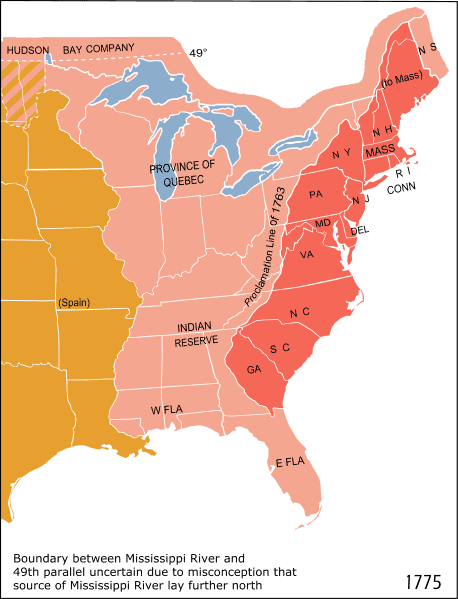
- The areas west of Quebec and west of a line extending along the top of the Allegheny Mountains were designated as (British) Indian Territory and colonists east of the line were banned from settling.
- The proclamation line was not intended to be a permanent barrier between colonists and Indigenous peoples’ territory but rather a temporary boundary that might be extended further west in a legitimate and orderly manner. It was also intended to be something other than an impenetrable barrier – people might pass it but not settle beyond it.
- The line’s shape was established by the headwaters that formed the Appalachian watershed. All land with rivers flowing into the Atlantic was set aside for colonial entities, whereas all land with rivers flowing into the Mississippi was set apart for Indigenous peoples’ inhabitants.
- The proclamation prohibited the private purchase of Indigenous peoples’ land, which had previously caused problems. Instead, Crown authorities were to make all future property purchases at some public Meeting or Assembly of the said Indigenous peoples.
- British colonials were prohibited from settling on native territory, and colonial officials were prohibited from granting ground or lands without royal permission. Land concessions were refused to organised land firms by King George III.
- The Indigenous peoples protested the proclamation boundaries because the British government had previously granted land grants to British colonists and land speculators. Among those who objected to the line were the affluent proprietors of the Ohio corporation, who had ambitions to settle the land and expand their business.
- Many communities existed beyond the proclamation line, some of which had been temporarily evacuated during Pontiac’s War, and many previously granted land claims remained unresolved.
- For example, George Washington and his Virginia troops were awarded property outside the boundary. Prominent American colonials joined up with British land speculators to persuade the government to shift the border further west.
- In a series of treaties with the Indigenous peoples, the colonists’ demands were met, and the boundary line was changed. In 1768, the Treaty of Hard Labor was established, which adjusted the border with the Cherokee nation in the Carolinas, and the Treaty of Fort Stanwix, which corrected the border with the Iroquois Confederacy in the Ohio Country.
- The objective of the Treaty of Fort Stanwix was to settle disputes among Indigenous peoples west of the colonies. Still, it had far-reaching consequences for the British-American colonies and, eventually, the new United States of America.
- The Treaty of Hard Labor was signed on 17 October 1768 and established a boundary line from the confluence of the Ohio and Kanawha Rivers to the Kanawha River’s headwaters, then south to Spanish East Florida.
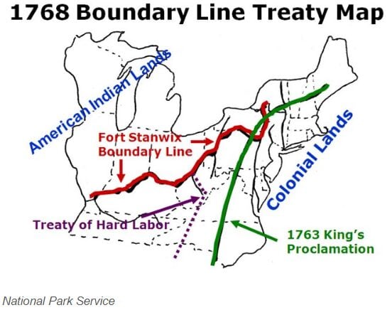
The Boundary Line Map of 1768 moved the boundary west - The Treaty of Lochaber followed the Treaty of Hard Labor in 1770, which adjusted Virginia’s boundary with the Cherokee. These treaties allowed British settlement in much of Kentucky and West Virginia. The land supplied by the Virginia and North Carolina governments benefited land firms because they had more wealthy backers than impoverished people hoping to make a fortune in the West.
RESPONSE FROM COLONISTS
- Finally, the new acquisitions failed to quell colonial resentment with the 1763 Proclamation. Though it was later overshadowed by other complaints against the British, such as the Sugar Act, Stamp Act, Townshend Acts, the Intolerable Acts, and the Boston Incident, it remained significant enough that King George III was chastised in the Declaration of Independence for raising the conditions of new land appropriations.
- The Declaration of Independence, subtitled The Unanimous Declaration of the thirteen United States of America, is the country’s foundational document. The Second Continental Congress sitting at the Pennsylvania State House, subsequently renamed Independence Hall, in Philadelphia accepted it on 4 July 1776.
- The Americans declared the Proclamation obsolete when they won independence from the British in 1783. It has, however, survived to the present day in Canada, where it serves as the legal basis for Indigenous land rights.
- Many colonists ignored the proclamation line and settled west, causing conflict with Indigenous peoples.
- The British government acquired control of many forts that commanded the waterways involved in regional trade and export to Great Britain. The colonists believed that the declaration took away their right as British citizens to move freely.
LEGACY OF THE ACT
- The Proclamation Line of 1763 governed the cession of Indigenous land in British North America, particularly in Upper Canada and Rupert’s Land, for many years. Based on the Proclamation, Upper Canada established a foundation for treaty-making. The initial impulse was produced by necessity after loyalists moved into territory following Britain’s loss in the American Revolution.
- The Royal Proclamation Line of 1763 is seen by some as a fundamental document for First Nations land claims and self-government. It is the first legal recognition of Aboriginal rights by the British Crown and imposes a fiduciary obligation of care on the Crown.
- The impact of the Royal Proclamation Line of 1763 on the outbreak of the American Revolution has been widely debated. Many historians suggest that after 1768, the Proclamation ceased to be a major source of conflict because the other treaties mentioned opened up vast regions for settlement.
Frequently Asked Questions
- What was the Proclamation Line of 1763?
The Proclamation Line of 1763 was a boundary established by the British government after the French and Indian War. It prohibited colonists from settling west of the Appalachian Mountains, aiming to prevent conflicts with the Indigenous peoples and stabilise relations on the western frontier.
- Why did the British government create the Proclamation Line of 1763?
The British government created the Proclamation Line to avoid conflicts between colonists and Indigenous peoples, reduce the costs of managing western territories, and maintain control over westward expansion in North America after the costly French and Indian War.
- How long was the Proclamation Line of 1763 in effect?
The Proclamation Line of 1763 was in effect until the end of the American Revolution 1783. After the Treaty of Paris was signed, recognising American independence, the boundary became obsolete as it no longer applied to the newly formed United States.